HIKING TRAILS
Boulder River Trail 734
- 4.3 miles each way
- Gain: 700 ft.
- Highest Point: 1550 ft.
This is a relatively easy, year round trail west of Darrington on Hwy 530. Here you will enjoy old growth trees and, within 1 mile, views of waterfalls crashing into the river from the steep banks opposite the trail. Those, who continue to the trails end, will be rewarded by a nice lunch spot beside the river. In earlier times, the route continued beyond "The Ford" at Boulder River. This was how the Three Fingers Lookout was accessed by forest fire lookouts from Darrington.
For current trail information go to the Washington Trails Association website.
Driving directions:
From I-5 take exit 208, east towards Arlington. At the junction of Hwy 530 and Hwy 9 get in the left hand turn lane and on to Hwy 9. Immediately take the next right and continue to follow Hwy 530 eastward towards Darrington. You will see signs for Boulder River Trail 1/4 mile prior to turning right onto French Creek Road, just after milepost 41. Follow French Creek Road to its end. There is parking for about 15 cars but no facilities at the trailhead . There is a vault toilet back towards Hwy 530 .
- 27 miles each way
- Hiking, Bicycles and Equestrian
The Whitehorse Trail is managed by Snohomish County Parks. At 27 miles in length, the trail connects the cities of Arlington and Darrington through a corridor that winds through farms, forests, and river environments, frequently paralleling Hwy 530. A section of the trail, from Darrington, west to Fortson Mill Trailhead, is open to the public. The remainder of Whitehorse trail is under construction from Trafton to Swede Heaven and is expected to be completed October 2019. Just east of Arlington the trail is impassable due to a landslide and will remain closed until engineers can assess earth movement the is occurring above and below the trail. No date has been determined for project completion. For additional information please contact Snohomish County Parks at (425)388-6610.
More information about the Whitehorse Trail restoration efforts can be found here.
The Mine Road Trail
- 2 miles each way
A beautiful afternoon hike up an abandoned road to an old mine near Darrington. The Mine Road is lovely in the spring, with blooms and berries, including trillium, yellow violets, and salmonberries. Amble two miles to the mine, passing Moose and Furland Creeks along the way, and coming to your destination, situated just across from Larson Creek. Scramble along the old Ashton Creek dry bed past the mine for about 150 yards for good views of Whitehorse Mountain and its many waterfalls in the summertime. This is the same trailhead as for the Neiderprum Trail (marked junction on right in 1.25 miles).
For current trail information go to the Washington Trails Association website.
North Fork Sauk Road 49 Hiking
North Fork Sauk Falls 660
- Length: 0.2 miles each way
- Elevation gain/loss is minimal
This short trail descends 200 feet to the base of a large waterfall. During the spring melt, the falls are at their most powerful as water surges down the 45 foot high falls. This is a good short hike to combine with Harold Engles Grove Trail.
For the most current trail information go to the Washington Trails Association website.
Driving Directions: From Darrington drive south on the Mt. Loop Hwy approximately 17 miles to Forest Service Road 49/ North Fork Sauk. Turn left onto Forest Service Road 49 and drive for 1.0 mile, the trailhead will be on your right.
Harold Engles Grove
- Length: 0.5 miles each way
- Elevation gain/loss is minimal
This short trail gently loops along a grove of enormous old growth cedars near the North Fork Sauk River. The grove is named in honor of legendary Darrington District Ranger Harold Engels who, so the story goes, refused to include this grove in a planned timber sale because he could not standby and allow these majestic cedars to be cut down.
Driving Directions: From Darrington drive south on the Mt. Loop Hwy approximately 17 miles to Forest Service Road 49/ North Fork Sauk. Follow Forest Service Road 49 for approximately 3.5 miles where you will see a sign board and trail head on your right.
Below are more trails on Forest Service Road 49. Current trail information is provided courtesy of the Washington Trails Association.
- Lost Creek Ridge Trail 646
- Sloan Peak Climbing Route
- North Fork Sauk Trail 649
- Bald Eagle/Curry Gap Trail 650
Suiattle River Road 26 Hiking
Current trail information below is courtesy of the Washington Trails Association.
- Boulder Lake Trail 740
- Huckleberry Trail 780
- Downey Creek Trail 768
- Green Mountain Trail 782
- Sulphur Mountain Trail 794
- Suiattle River Trail 784
- Miners Ridge Trail 785
- Pacific Crest Trail 2000
MOUNTAIN LOOP HWY. HIKING
Old Sauk Trail 728
- Length: 3 miles one way
- 1.3 miles Accessible Loop
- Elevation gain/loss is minimal
- Good hike with kids; accessible loop
This mossy trail winds through remnant old growth, mature second growth and young riparian forest as it follows the Sauk (pronounced “Sock”) River. The addition of a new, barrier free loop trail, accessed from the parking area near mile marker 48 on the Mt. Loop, makes this a good year round choice for hikers of all abilities. Look for sign of beaver or river otter otters playing in the rapids. Listen for the chirping of bald eagles as they perch over the river in search of fish to eat.
Driving directions: From Darrington, drive south on the Mt. Loop Hwy for approximately 4 miles. The north trail head for Old Sauk Trail is on your left. If you continue on the Mt. Loop for another 2 miles you will see the larger, barrier free loop trail head with picnic tables and a toilet. The southern trail head is another 0.6 miles beyond at a small paved pull-out at Murphy Creek.
- Length 2 miles one way
- Elevation gain/loss minimal
- Year round access
This trail is an easy hike designed to provide a view of beavers at work, soaring eagles or just a chance to enjoy the serenity of the river and forest. The entire trail follows the old Sauk River Lumber Company railroad – look for the old trestles in the river or rail exposed along the trail. From Beaver Lake bridge you may catch a glimpse of a beaver silently gliding through the water with a freshly chewed alder limb in its mouth. Beyond Beaver Lake, the trail ends at the river where the trail was washed out during high waters in 2006. Mt. Pugh , with its distinguished knobby top, can be seen from this location on a clear day.
Driving directions: From Darrington drive south on the Mt. Loop Hwy, following the Sauk (pronounced “Sock”) River for approximately 10 miles. On your right you will see the Beaver Lake Trail head parking lot and toilet.
- Length: 7 miles each way
- Elevation gain/loss is minimal
- Good hike with kids and dogs under control
This is a delightful trail that meanders through a moss blanketed forest, with occasional glimpses of the White Chuck River and Mt Pugh. After crossing a footbridge at Black Oak Creek and walking for another 1.0 miles, the trail eventually grows fainter at which point you will need to turn around and retrace your steps. Forest Service and Washington Trails Association (WTA) crews have been busy brushing and repairing tread with the goal of getting the trail opened all the way to end at Crystal Creek. Check WTA.org for future work parties.
Driving Directions: From Darrington, take the Mt. Loop Highway for approximately 10 miles. Take a left and cross the White Chuck Bridge, driving past the White Chuck Boat Launch, uphill, to a small flat parking area on the left with a bulletin board across the road where the trail begins.
Current trail information below is courtesy of the Washington Trails Association.
WILD FLOWERS
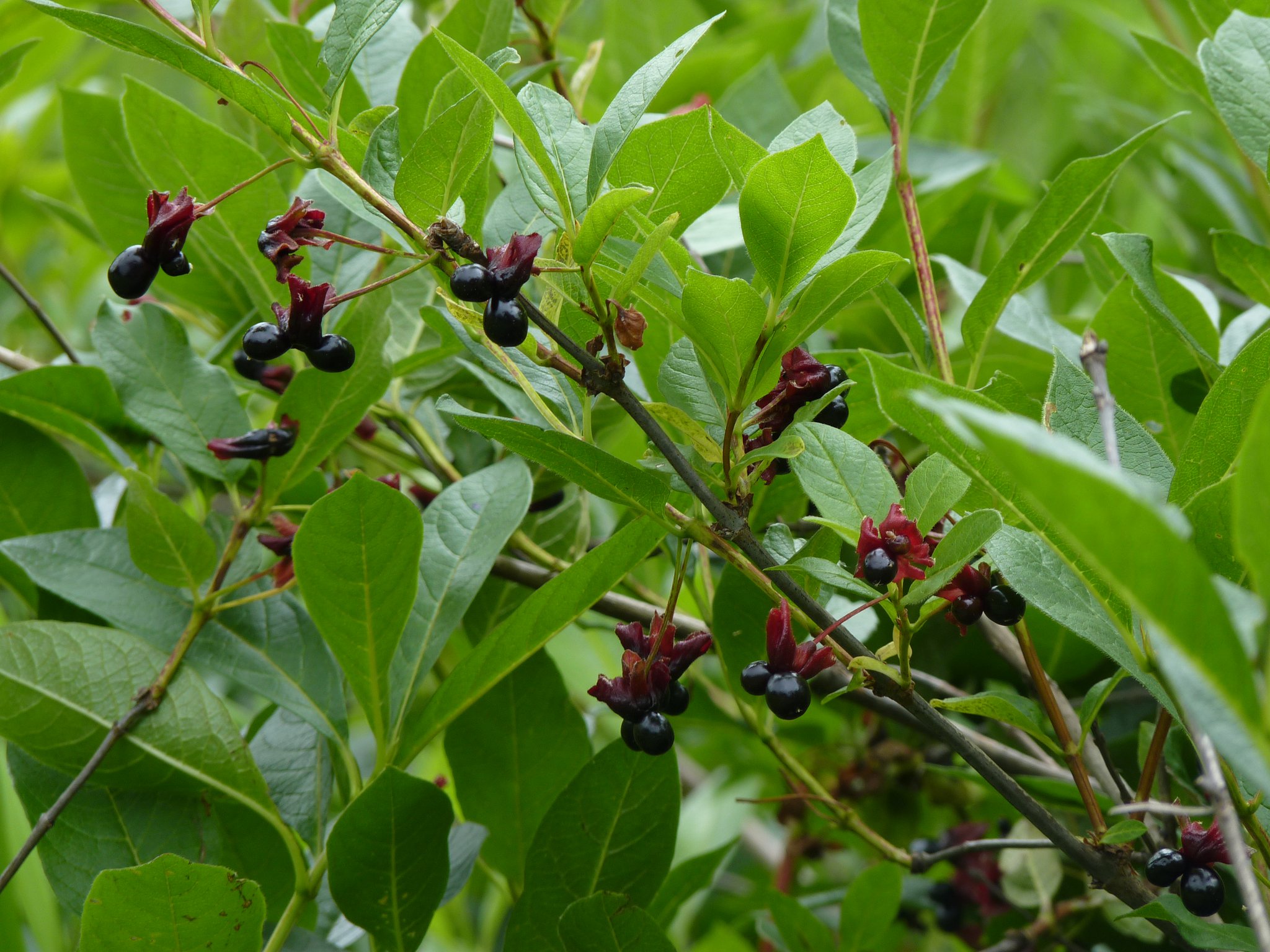
The Black Twin-berry is in the Honeysuckle family. This woody 3 to 6 foot shrub produces "twin" yellow flowers in mid-spring through late summer, and "twin" black berries follow. The large leaves of Black Twin-berry can grow up to 5 inches long, prominently veined and slightly hairy.
Another name for Black Twin-berry is "Fly Honeysuckle", there are several theories as to why this plant was given this common name. Flies do pollinate the flowers, as well do butterflies and bees.Another theory is the resemblance the berries have to large black flies.
May – September


